The Hiking Thread
-
O Really

- Admiral
- Posts: 23825
- Joined: Tue Sep 18, 2012 3:37 pm
Re: The Hiking Thread
So according to the article the problem isn't when neoplacebo looks for crawdads, but when many people move around a lot of rocks over time. Pretty much the same principle as anything else in the forest: one guy may be able to scramble down a non-trail without harm but if a lot of guys do it over time it will erode, slide, etc. That really needs to be emphasized, otherwise any statement of potential harm from a cairn here and there isn't going to make sense. I read a similar article a couple of years ago without that context and I never did understand how some random fish having to find another rock to stay under was going to cause the Armageddon implied. This one was much better written.
-
O Really
- Admiral
- Posts: 23825
- Joined: Tue Sep 18, 2012 3:37 pm
Re: The Hiking Thread
Speaking of hiking, we went to one of our favourite "close-ish" trails yesterday in Rancho Bernardo. The area has an interesting history, and began as an early version planned community back in the late 60's, carved out of part of a 60,000 acre privately owned ranch. https://www.alltrails.com/parks/us/cali ... earch=true
The entire park consists of a recreation area with ball fields, tennis courts, senior/community center, picnic area, etc. plus a large natural area left mostly unchanged since the Kumeyaay Indians lived there for 10,000 years before there was a San Diego. https://viejasbandofkumeyaay.org/viejas ... y-history/
We like the The Piedras Pintadas Trail, which "winds around Lake Hodges’ Bernardo Bay, with detailed interpretive signs about the Kumeyaay technologies: the preparation of food, tools, weapons, and how they used various plants. A pictograph site is now off limits due to vandalism. The trailhead begins in northwest Rancho Bernardo, south of the parking lot off West Bernardo Drive. For those able to complete the 3.8-mile round trip, there are more interpretive signs about Kumeyaay resource management techniques on the western side of the Ridge Loop Trail."
Since much of the old types of vegetation still grows there, it's interesting to see how many different uses the indigenous people had for essentially everything in their environment. And yesterday it was also full of wildflowers, as an added bonus.
-
Vrede too

- Superstar Cultmaster
- Posts: 59939
- Joined: Fri Apr 03, 2015 11:46 am
- Location: Hendersonville, NC
Re: The Hiking Thread
Who knew?
I've always relied on water, saving oral rehydration solutions for diarrheal diseases.The most hydrating beverages, ranked
The research team at St. Andrews University tested 13 common beverages to see how they impact hydration. Here’s what they found, ranked from most hydrating over a four-hour period to least.
Skim milk
Oral rehydration solutions (like Pedialyte or Liquid I.V.)
Full fat milk
Orange juice
Cola
Diet Cola
Cold tea
Tea
Sports drink
Still water
Sparkling water
Lager
Coffee
Last edited by Vrede too on Sat Jul 15, 2023 4:37 pm, edited 2 times in total.
Lament the murder, not the murdered.
1312. ETTD. 86 47.
1312. ETTD. 86 47.
-
GoCubsGo

- Admiral
- Posts: 23536
- Joined: Sun Sep 23, 2012 2:22 am
Re: The Hiking Thread
Coke?Vrede too wrote: ↑Sat Jul 15, 2023 4:02 pmWho knew?I've always relied on water, saving oral rehydration solutions for diarrheal diseases.The most hydrating beverages, ranked
The research team at St. Andrews University tested 13 common beverages to see how they impact hydration. Here’s what they found, ranked from most hydrating over a four-hour period to least.
Skim milk
Oral rehydration solutions (like Pedialyte or Liquid I.V.)
Full fat milk
Orange juice
Cola
Diet Cola
Cold tea
Tea
Sports drink
Still water
Sparkling water
Lager
Coffee
Coffee?
Beer?
I thought caffeine and alcohol were diuretics and not only not helpful but hurtful.
Eamus Catuli~AC 000000 000101 010202 020303 010304 020405....Ahhhh, forget it, it's gonna be a while.
Foxtrot
Delta
Tango
Foxtrot
Delta
Tango
-
Vrede too
- Superstar Cultmaster
- Posts: 59939
- Joined: Fri Apr 03, 2015 11:46 am
- Location: Hendersonville, NC
Re: The Hiking Thread
Vrede too wrote: ↑Sat Jul 15, 2023 4:02 pmWho knew?I've always relied on water, saving oral rehydration solutions for diarrheal diseases.The most hydrating beverages, ranked
The research team at St. Andrews University tested 13 common beverages to see how they impact hydration. Here’s what they found, ranked from most hydrating over a four-hour period to least.
Skim milk
Oral rehydration solutions (like Pedialyte or Liquid I.V.)
Full fat milk
Orange juice
Cola
Diet Cola
Cold tea
Tea
Sports drink
Still water
Sparkling water
Lager
Coffee
Sorry, your whiskey espressos will still dehydrate you.... Alcohol acts as a diuretic, which causes you to pass more urine, so when it comes to alcoholic beverages hydration will depend on a beverage’s total volume. “Beer would result in less water loss than whiskey, because you are ingesting more fluid with beer,” Maughan said. “Strong alcoholic drinks will dehydrate, dilute alcoholic drinks will not.”
When it comes to coffee, how well your java hydrates you will depend on the amount of caffeine you consume. A regular coffee with about 80 milligrams of caffeine — roughly what you would find in 12 oz. of Folgers’ house blend – would be pretty much as hydrating as water, according to Maughan’s research.
Consuming more than 300mg of caffeine, or about 2-4 cups of coffee, could cause you to lose excess fluid as the caffeine causes a mild, short-term diuretic effect. This is more likely to happen with someone who doesn’t typically consume caffeine, and it could be offset by adding a tablespoon or two of milk to your cup of joe.
Milk and orange juice - mama was right.
Lament the murder, not the murdered.
1312. ETTD. 86 47.
1312. ETTD. 86 47.
-
neoplacebo

- Admiral of the Fleet
- Posts: 12770
- Joined: Mon Sep 17, 2012 1:42 pm
- Location: Kingsport TN
Re: The Hiking Thread
I've found that increasing intake of beer during hot days is not unpleasant. And so far, I've not suffered any sort of dehydration. I expect this to continue.
-
GoCubsGo
- Admiral
- Posts: 23536
- Joined: Sun Sep 23, 2012 2:22 am
Re: The Hiking Thread
What was I thinking?neoplacebo wrote: ↑Sun Jul 16, 2023 8:36 amI've found that increasing intake of beer during hot days is not unpleasant. And so far, I've not suffered any sort of dehydration. I expect this to continue.
Eamus Catuli~AC 000000 000101 010202 020303 010304 020405....Ahhhh, forget it, it's gonna be a while.
Foxtrot
Delta
Tango
Foxtrot
Delta
Tango
-
O Really
- Admiral
- Posts: 23825
- Joined: Tue Sep 18, 2012 3:37 pm
Re: The Hiking Thread
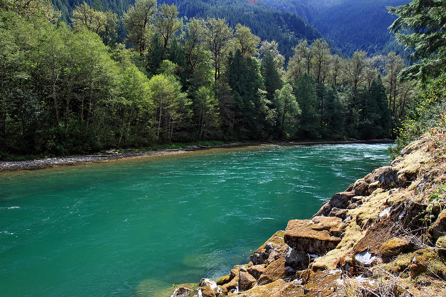
Today's road trip/hike was to Manning Park https://bcparks.ca/ec-manning-park/ in the North Cascades. Beautiful park with good trails. It's also the origin of the Skagit River, that flows with a beautiful green color because of ... "Gneiss (pronounced “nice”) is coarse-grained metamorphic rock with a banded structure. What makes glacial flour from Skagit gneiss so… well, nice is the mineral olivine, which, as you might have guessed from its name, is a gorgeous green. In fact, olivine is the mineral that makes up the gemstone peridot."
-
O Really
- Admiral
- Posts: 23825
- Joined: Tue Sep 18, 2012 3:37 pm
Re: The Hiking Thread
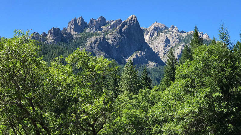
So today's hike was intended to be a few miles on the Pacific Crest Trail ("PCT"). Not that we're ever going to be through-hikers, and likely wouldn't have been decades ago either, but we enjoy hiking on the big trails. We've hiked on parts of the Appalachian Trail in I think 9 of the 11 states it goes through. The PCT is longer, but only goes through CA, OR, and WA and we already hike it in OR and WA. But we were accessing the trail close to Castle Crags State Park, and got sidetracked by going into the park. The road up to Vista Point (below) was narrow and windy even for a Jeep, but well worth it at the top. We still made it onto the PCT, but since it went steeply up for about two miles from the trailhead, it wasn't exactly a casual walk in the woods.
https://inspiredimperfection.com/advent ... int-trail/
https://inspiredimperfection.com/advent ... int-trail/
-
O Really
- Admiral
- Posts: 23825
- Joined: Tue Sep 18, 2012 3:37 pm
Re: The Hiking Thread
Today's adventure was Lassen Volcanic National Park https://www.nps.gov/lavo/index.htm. Took a trail named "Bumpass Hell" which was neither an assbumper nor particularly difficult. https://www.nps.gov/thingstodo/hikebumpasshell.htm Only three miles round trip, it goes through some strong hydrothermal areas via boardwalk. Pretty cool to be walking around on a volcano that's slightly bubbling beneath your feet. At over 8,000 feet, though, it's a bit more effort than it would seem.
There's a trail (that we didn't take) that goes all the way to the summit. It's about 2,000 foot gain in about two miles (including switchbacks) https://www.nps.gov/thingstodo/hikelassenpeak.htm but there were some people trucking right up it - including some kids.
Lot of damage from the big Dixie fire from 2021 that affected over half the park.
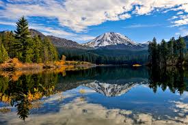
We took our version of the pic below across from Lake Manzanita, but everybody gets the same pic. There's a marker that says, in effect, "stand here - point that way. Click" Still a good pic, though.
There's a trail (that we didn't take) that goes all the way to the summit. It's about 2,000 foot gain in about two miles (including switchbacks) https://www.nps.gov/thingstodo/hikelassenpeak.htm but there were some people trucking right up it - including some kids.
Lot of damage from the big Dixie fire from 2021 that affected over half the park.
We took our version of the pic below across from Lake Manzanita, but everybody gets the same pic. There's a marker that says, in effect, "stand here - point that way. Click" Still a good pic, though.
-
GoCubsGo
- Admiral
- Posts: 23536
- Joined: Sun Sep 23, 2012 2:22 am
Re: The Hiking Thread
How are the colors?
Eamus Catuli~AC 000000 000101 010202 020303 010304 020405....Ahhhh, forget it, it's gonna be a while.
Foxtrot
Delta
Tango
Foxtrot
Delta
Tango
-
O Really
- Admiral
- Posts: 23825
- Joined: Tue Sep 18, 2012 3:37 pm
Re: The Hiking Thread
Birches are a spectacular bright gold. And plentiful. Most everything else left up there was evergreens.
We had eye-popping colour in Oregon, with maples, birches, and oaks. We're off next to wine country where the vineyards should be really good.
-
O Really
- Admiral
- Posts: 23825
- Joined: Tue Sep 18, 2012 3:37 pm
Re: The Hiking Thread
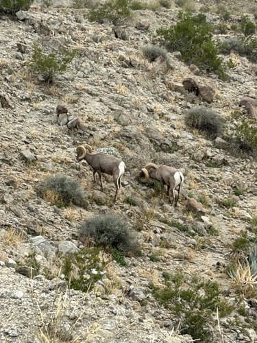
Today's hike could be described in two words: "rocky" and "up" but it was worth the effort to get the top views and the Bighorn Sheep sightings.
https://www.alltrails.com/trail/us/cali ... loop-trail
https://www.alltrails.com/trail/us/cali ... loop-trail
-
GoCubsGo
- Admiral
- Posts: 23536
- Joined: Sun Sep 23, 2012 2:22 am
Re: The Hiking Thread
Tourons of California?O Really wrote: ↑Tue Dec 26, 2023 9:13 pmToday's hike could be described in two words: "rocky" and "up" but it was worth the effort to get the top views and the Bighorn Sheep sightings.
https://www.alltrails.com/trail/us/cali ... loop-trail
Eamus Catuli~AC 000000 000101 010202 020303 010304 020405....Ahhhh, forget it, it's gonna be a while.
Foxtrot
Delta
Tango
Foxtrot
Delta
Tango
-
O Really
- Admiral
- Posts: 23825
- Joined: Tue Sep 18, 2012 3:37 pm
Re: The Hiking Thread
Probably are some. These critters are fairly tameish because the hiking trail is very popular. Notes in of the comments on All trails said he saw some cool "goats"
-
O Really
- Admiral
- Posts: 23825
- Joined: Tue Sep 18, 2012 3:37 pm
Re: The Hiking Thread
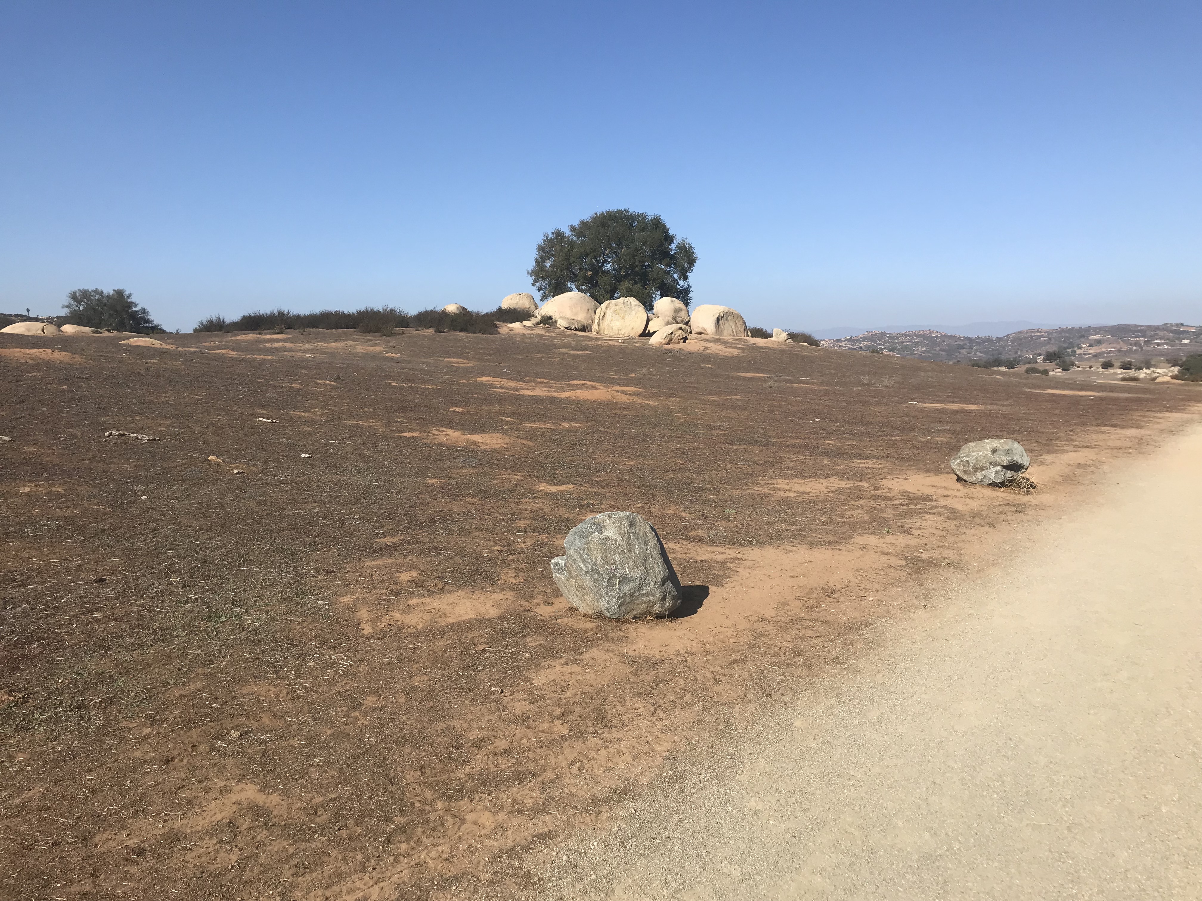
I don't usually jump through the hoops to post one of my own pics, but this is one of the better landscape shots I've taken. It's in an area called "Ramona Grasslands" near the town of Ramona, about halfway up the mountains between the coast and the desert. So we live a couple of hundred yards from the ocean, and this view is about 45 minutes away, with any traffic luck.
- Attachments
-
-
GoCubsGo
- Admiral
- Posts: 23536
- Joined: Sun Sep 23, 2012 2:22 am
Re: The Hiking Thread
That's not too shabby, not too mention there's actually green.O Really wrote: ↑Tue Apr 16, 2024 10:31 pmI don't usually jump through the hoops to post one of my own pics, but this is one of the better landscape shots I've taken. It's in an area called "Ramona Grasslands" near the town of Ramona, about halfway up the mountains between the coast and the desert. So we live a couple of hundred yards from the ocean, and this view is about 45 minutes away, with any traffic luck.
Eamus Catuli~AC 000000 000101 010202 020303 010304 020405....Ahhhh, forget it, it's gonna be a while.
Foxtrot
Delta
Tango
Foxtrot
Delta
Tango
-
O Really
- Admiral
- Posts: 23825
- Joined: Tue Sep 18, 2012 3:37 pm
Re: The Hiking Thread
Yeah, so if you didn't know where it was, how long would it take you to guess "35 miles from downtown San Diego"GoCubsGo wrote: ↑Wed Apr 17, 2024 1:30 amThat's not too shabby, not too mention there's actually green.O Really wrote: ↑Tue Apr 16, 2024 10:31 pmI don't usually jump through the hoops to post one of my own pics, but this is one of the better landscape shots I've taken. It's in an area called "Ramona Grasslands" near the town of Ramona, about halfway up the mountains between the coast and the desert. So we live a couple of hundred yards from the ocean, and this view is about 45 minutes away, with any traffic luck.
-
GoCubsGo
- Admiral
- Posts: 23536
- Joined: Sun Sep 23, 2012 2:22 am
Re: The Hiking Thread
Based on your picture, quite a while.
Based on some other pics, not as long.
Guessing it's seasonal or maybe unusual due to the amount of rain southern California has received.
Eamus Catuli~AC 000000 000101 010202 020303 010304 020405....Ahhhh, forget it, it's gonna be a while.
Foxtrot
Delta
Tango
Foxtrot
Delta
Tango
-
Whack9

- Captain
- Posts: 4679
- Joined: Fri Jul 20, 2018 12:31 pm
Re: The Hiking Thread
Idk if they grow in the San Diego area but it's morel season around the US so be in the lookout. It's wrapping up here though. I have managed to find zero morels anywhere except under my deck. But I did manage to snag a tick bite.