NOAA issues highest-ever early forecast for the coming hurricane season
... NOAA predicts eight to 13 hurricanes and 17 to 25 named storms. Storms get names when their wind speeds reach 39 mph or higher.
Given the near-record warmth in much of the Atlantic Ocean and a strong chance of La Niña conditions, forecasters said there is an 85% chance of an above-normal season along the Atlantic seaboard....
Hurricane season begins June 1 and ends November 30. It typically starts to peak in late summer and early fall.
Global warming increases hurricanes' propensity for damaging effects. A warmer atmosphere makes the storms more likely to rapidly pick up wind speed as they near the shore. And when storms make landfall, climate change is increasing the probability they will stall and drop rainfall at extreme rates.
NOAA is far from alone in making such a prediction for this hurricane season.
Nearly every public, private and government hurricane forecast service is expecting a high season for hurricanes and named storms, according to a website operated by Colorado State University and the Barcelona Supercomputing Center, which tracks predictions each year. The site has aggregated early hurricane forecasts from 23 centers.
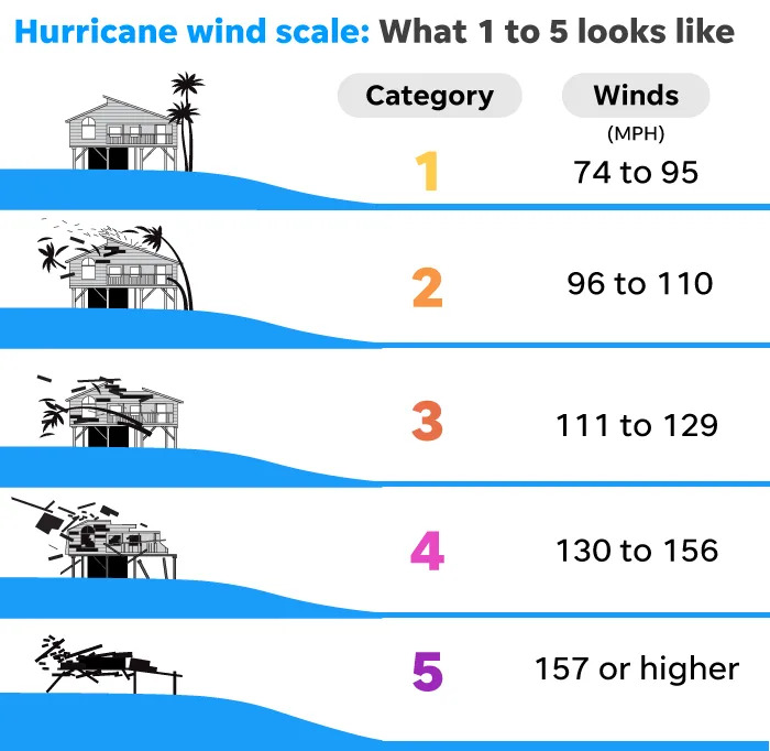
The NOAA forecast is in line with the aggregate. On average, the services have predicted 23 named storms, 11 hurricanes and five major hurricanes (the designation given to storms that reach Category 3 or higher, based on their wind speeds).
“When it comes to the number of storms, that would be the third most on record,” said Philip Klotzbach, a meteorologist at Colorado State University who specializes in Atlantic basin seasonal hurricane forecasts.
In 2020, there were 30 named storms, the most in observed history. Twelve of the storms made landfall in the United States and every mile of the mainland Atlantic coast was placed on a hurricane warning or watch at some point during that season, according to Yale Climate Connections.
Last year, 20 named storms formed in the Atlantic, including 7 hurricanes.
It’s unusual to see record sea surface temperatures coincide with a strong chance of La Niña — a natural climate pattern associated with Atlantic hurricane. The combination strengthens forecasters' confidence that this season could be significant....
Worldwide, sea surface temperatures have remained record hot for more than a year. McNoldy said Caribbean temperatures are warmer in May than they are at peak in a typical year. In the tropical east Atlantic, temperatures today are comparable to what's normal for August.
Record sea surface temperatures could fuel rapid intensification, a phenomenon in which hurricane winds ramp up suddenly as the storm nears shore. Climate change makes that process more likely.
A study last year found that tropical cyclones in the Atlantic Ocean were about 29% more likely to undergo rapid intensification from 2001 to 2020, compared to 1971 to 1990. Hurricane Idalia, which strengthened from Category 1 to Category 4 in just 24 hours, is a good example.
The trend makes hurricane preparations more challenging — officials have less time to warn communities, deploy emergency resources and help people evacuate....


 Haiyan, November 2013: Struck the southern Philippines with 196-mph winds and a storm surge of almost 25 feet, killing 6,300 people and leaving 4 million homeless.