Single hurricane thread

Generally an unmoderated forum for discussion of pretty much any topic. The focus however, is usually politics.
Post Reply
User avatar
Vrede too
Superstar Cultmaster
Posts: 51501
Joined: Fri Apr 03, 2015 11:46 am
Location: Hendersonville, NC

Re: Single hurricane thread

Unread post by Vrede too »

Aerial Footage Shows Devastation After Acapulco Ravaged by Hurricane Otis

... Otis struck the southwest of Mexico as a Category 5 storm on Wednesday and caused widespread devastation, destroying buildings, causing floods and shutting down communications. The storm has so far killed at least 27 people, according to the Mexican government. Wind speeds of 165 miles per hour were recorded, Reuters said.

A video shot from a helicopter over Acapulco, a city of approximately 900,000 people, illustrates the extent of the destruction.

The footage posted on X, formerly Twitter, by user Volcaholic shows the beach resort ravaged by the hurricane, with numerous boats in the harbor and bay upturned or submerged. Debris from buildings and trees can be seen strewn over what would usually be popular spots for tourists and locals.

A GIF posted by severe weather follower Nahel Belgherze shows a before and after of an apartment block, with the glazed shell of the building almost completely blown out.

Belgherze said on Twitter: "Hurricane Otis will more than likely go down as one of the costliest tropical cyclones ever recorded on Earth. Acapulco has literally been torn apart. Destruction everywhere."
:shock:


The hurricane flooded a local hospital, which had to evacuate its staff and patients, Reuters said....


The hurricane was fueled by a surge of ocean warmth, which is becoming more common as global temperatures increase. Otis's wind speeds increased by about 110 mph within 24 hours, meaning people in areas such as Acapulco had little time to prepare.

The US National Oceanic and Atmospheric Administration (NOAA) described Otis as a "life-threatening storm surge" which would bring large and dangerous waves, destructive winds and heavy rainfall. America's National Hurricane Center said: "There are no hurricanes on record even close to this intensity for this part of Mexico."
:cry:
A clown with a flamethrower still has a flamethrower.
-- Charlie Sykes on MSNBC
1312. ETTD.

User avatar
Vrede too
Superstar Cultmaster
Posts: 51501
Joined: Fri Apr 03, 2015 11:46 am
Location: Hendersonville, NC

Re: Single hurricane thread

Unread post by Vrede too »

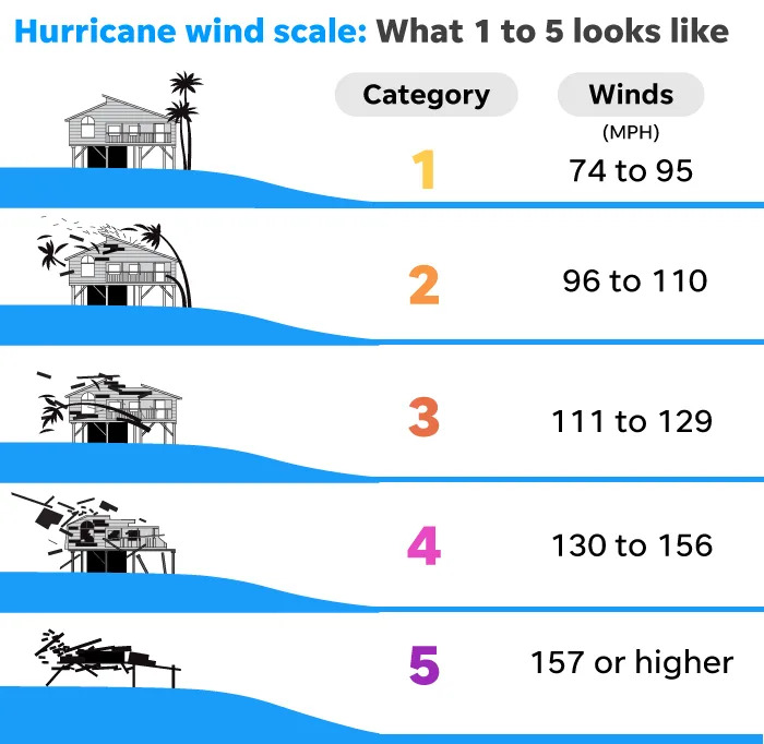
'Category 5' was considered the worst hurricane. There's something scarier, study says.

As fearsome as Category 5 hurricanes can be for people living in harm's way, a new study reports global warming is supercharging some of the most intense cyclones with winds high enough to merit a hypothetical Category 6....

They used a hypothetical Category 6, with a minimum threshold of 192 mph, to study hurricanes that have occurred in the modern satellite era, since around 1980. They found five hurricanes and typhoons that would have met the criteria and all five occurred within the last decade....

Image
The Saffir-Simpson scale categorizes hurricanes.

...

Image
This infrared satellite image shows Hurricane Patricia over the Pacific Ocean on Oct. 23, 2015.

Which storms fit the study’s hypothetical Category 6 description?

One hurricane in the eastern Pacific, Patricia, and four typhoons in the western Pacific:

◾ Haiyan, November 2013: Struck the southern Philippines with 196-mph winds and a storm surge of almost 25 feet, killing 6,300 people and leaving 4 million homeless.

◾ Patricia, October 2015: Reached winds of 216 mph at sea, then dropped before it made landfall in Jalisco, Mexico as a Category 4 storm.

◾ Meranti, September 2016: Moved between the Philippines and Taiwan before making landfall in eastern China. Its winds reached 196 mph.

◾ Goni, November 2020: Made landfall in the Philippines with winds estimated at 196 mph.

◾ Surigae, April 2021: Reached wind speeds of 196 mph over the ocean, tracking east of the Philippines. Its max winds were the highest ever recorded for a storm from January to April anywhere in the world.
Crap :problem:
A clown with a flamethrower still has a flamethrower.
-- Charlie Sykes on MSNBC
1312. ETTD.

User avatar
Vrede too
Superstar Cultmaster
Posts: 51501
Joined: Fri Apr 03, 2015 11:46 am
Location: Hendersonville, NC

Multiple hurricanes thread

Unread post by Vrede too »

NOAA issues highest-ever early forecast for the coming hurricane season

... NOAA predicts eight to 13 hurricanes and 17 to 25 named storms. Storms get names when their wind speeds reach 39 mph or higher.

Given the near-record warmth in much of the Atlantic Ocean and a strong chance of La Niña conditions, forecasters said there is an 85% chance of an above-normal season along the Atlantic seaboard....

Hurricane season begins June 1 and ends November 30. It typically starts to peak in late summer and early fall.

Global warming increases hurricanes' propensity for damaging effects. A warmer atmosphere makes the storms more likely to rapidly pick up wind speed as they near the shore. And when storms make landfall, climate change is increasing the probability they will stall and drop rainfall at extreme rates.

NOAA is far from alone in making such a prediction for this hurricane season.

Nearly every public, private and government hurricane forecast service is expecting a high season for hurricanes and named storms, according to a website operated by Colorado State University and the Barcelona Supercomputing Center, which tracks predictions each year. The site has aggregated early hurricane forecasts from 23 centers.

The NOAA forecast is in line with the aggregate. On average, the services have predicted 23 named storms, 11 hurricanes and five major hurricanes (the designation given to storms that reach Category 3 or higher, based on their wind speeds).

“When it comes to the number of storms, that would be the third most on record,” said Philip Klotzbach, a meteorologist at Colorado State University who specializes in Atlantic basin seasonal hurricane forecasts.

In 2020, there were 30 named storms, the most in observed history. Twelve of the storms made landfall in the United States and every mile of the mainland Atlantic coast was placed on a hurricane warning or watch at some point during that season, according to Yale Climate Connections.

Last year, 20 named storms formed in the Atlantic, including 7 hurricanes.

It’s unusual to see record sea surface temperatures coincide with a strong chance of La Niña — a natural climate pattern associated with Atlantic hurricane. The combination strengthens forecasters' confidence that this season could be significant....

Worldwide, sea surface temperatures have remained record hot for more than a year. McNoldy said Caribbean temperatures are warmer in May than they are at peak in a typical year. In the tropical east Atlantic, temperatures today are comparable to what's normal for August.

Record sea surface temperatures could fuel rapid intensification, a phenomenon in which hurricane winds ramp up suddenly as the storm nears shore. Climate change makes that process more likely.

A study last year found that tropical cyclones in the Atlantic Ocean were about 29% more likely to undergo rapid intensification from 2001 to 2020, compared to 1971 to 1990. Hurricane Idalia, which strengthened from Category 1 to Category 4 in just 24 hours, is a good example.

The trend makes hurricane preparations more challenging — officials have less time to warn communities, deploy emergency resources and help people evacuate....
:problem:
A clown with a flamethrower still has a flamethrower.
-- Charlie Sykes on MSNBC
1312. ETTD.

Post Reply